The global mapping and navigation business has been steadily expanding its use of GIS. Instead of manually assimilating data, the worldwide mapping and navigation sector uses new technologies such as GIS, GPS, and Remote sensing instead of the outdated technique of manual assimilation.
Utility Surveying and Mapping (Power, Telecom, Water, Sewer & Gas)
Utility mapping is accurately surveying and plotting the position and depth of the detected utilities. Combination DGPS / Electronic Total Station / Drone / GPR Surveying Techniques adopted to prepare subsurfaces (underground) utility maps, such as Water pipeline networks, Electrical cable networks, Gas or Oil pipelines, Sewers and Drainage networks, and Telecommunication fibre optical cables for the Urban Local Bodies.
SenseImage can provide all kinds of network and supply distribution systems and schemes. We also prepared detailed CAD drawings, the execution plan, and the project report.
▪ Data model designing ▪ Perform analysis of network data. ▪ GIS Network clean up as per Topology placement rule ▪ Validating the network based on stated validation rules ▪ Create an error-free Data model to use with outage management ▪ Develop custom tools and quality control.
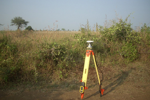
DGPS Survey or Total Station
Using modern DGPS (Differential Global Positioning System), SenseImage conduct a topographical survey using DGPS for pipeline networks, Ground Control Points, Demarcation Forests, and Bench Marks. Road levelling project of Municipality (with 10m/20m intervals) collect with the help of an advanced form of Kinematic DGPS and prepare a map with the profile. We use Electronic Total Station where GPS Antenna not getting an adequate signal.
Volume Estimation of Lakes and Mines
Remote Sensing and Digital Image Processing Techniques are used to calculate the volume of lake water (also to estimate the depth of silt) in hydrological or Mining projects. It was achieved by using digital image processing in an open-source software environment (QGIS, GRASS, SAGA). SenseImage uses LiDAR data or UAV photogrammetry or satellite imagery as point clouds, which are then converted into a Digital Elevation Model (DEM) to create depth information on a grid basis.
mapping
The team chose to utilize a UAV with one simple reason: no other method of data collecting could provide the required image in the short period of time available.
Using traditional on-site field surveys to map this complex area would have taken us weeks; in some places, it is completely impractical due to the impenetrable density of the flora. One of SENSEIMAGE TECHNOLOGIES, have many innovative solutions, mapping now benefits the mining, coal, & gold-digging industries. Our company represents these industries by providing products like volumetric analysis, 3D model development in obj format, Orth mosaic photos, 2D and 3D Topographical base maps, and Digital Elevation Model with spatial resolution using specialized software.
Future design allows to extending the drones endurance as the inclusion of a broad range of mapping payload to increase mapping efficiency.